


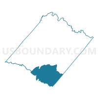
Partlow Voting District, Spotsylvania County, Virginia
About
Outline

Summary
| Unique Area Identifier | 682584 |
| Name | Partlow Voting District |
| County | Spotsylvania County |
| State | Virginia |
| Area (square miles) | 52.70 |
| Land Area (square miles) | 49.34 |
| Water Area (square miles) | 3.36 |
| % of Land Area | 93.62 |
| % of Water Area | 6.38 |
| Latitude of the Internal Point | 38.05238410 |
| Longtitude of the Internal Point | -77.67074360 |
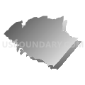
Maps


Graphs
Select a template below for downloading or customizing gragh for Partlow Voting District, Spotsylvania County, Virginia


Neighbors
Neighoring Voting District (by Name) Neighboring Voting District on the Map
- Beaverdam Voting District, Hanover County, VA
- Blaydes Corner Voting District, Spotsylvania County, VA
- Brokenburg Voting District, Spotsylvania County, VA
- Bumpass Voting District, Louisa County, VA
- Chilesburg Voting District, Caroline County, VA
- Fredericks Hall Voting District, Louisa County, VA
- Madison Voting District, Caroline County, VA
Top 10 Neighboring County Subdivision (by Population) Neighboring County Subdivision on the Map
- Livingston district, Spotsylvania County, VA (17,099)
- Berkeley district, Spotsylvania County, VA (16,437)
- Beaverdam district, Hanover County, VA (12,879)
- Madison district, Caroline County, VA (9,818)
- Jackson district, Louisa County, VA (4,972)
- Cuckoo district, Louisa County, VA (4,623)
Top 10 Neighboring Unified School District (by Population) Neighboring Unified School District on the Map
- Spotsylvania County Public Schools, VA (122,397)
- Hanover County Public Schools, VA (99,863)
- Louisa County Public Schools, VA (33,153)
- Caroline County Public Schools, VA (28,545)
Top 10 Neighboring State Legislative District Lower Chamber (by Population) Neighboring State Legislative District Lower Chamber on the Map
- State House District 54, VA (99,135)
- State House District 56, VA (95,097)
- State House District 97, VA (87,705)
- State House District 55, VA (81,482)
Top 10 Neighboring State Legislative District Upper Chamber (by Population) Neighboring State Legislative District Upper Chamber on the Map
Top 10 Neighboring 111th Congressional District (by Population) Neighboring 111th Congressional District on the Map
Top 10 Neighboring Census Tract (by Population) Neighboring Census Tract on the Map
- Census Tract 305, Caroline County, VA (11,752)
- Census Tract 9501, Louisa County, VA (7,040)
- Census Tract 3201, Hanover County, VA (6,367)
- Census Tract 204.03, Spotsylvania County, VA (3,785)
- Census Tract 204.04, Spotsylvania County, VA (3,426)
- Census Tract 304, Caroline County, VA (1,899)